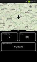
Own personal flight tracker, speed and altitude while flying in the air
YOU CAN DO IT ON A PLANE!
Es gibt eine kostenpflichtige Flugkarte, die Datenbank von Weltflughäfen, die geschätzte Ankunftszeit und die Aufzeichnung der Flasser -Route enthält, die in sozialen Netzwerken gemeinsam genutzt werden kann. Nachdem Sie die Flight Map FREE ausprobiert haben, erwägen Sie möglicherweise ein Upgrade. Or, you might consider upgrading to Flight Map HD, which has much more detailed map of the world.
Flight Map FREE is a unique application that works as your own personal flight tracker (Sky map) while flying in an airplane. It shows where you currently are, speed, altitude and some other information about your flight. You can also see and name the landmarks on the way, so that you know what you see from your window.
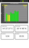
Flight Map FREE also displays visible and used GPS / GLONASS satellites, so you can use it as a GPS testing tool. Die GPS -Funktion funktioniert, wenn sich Ihr Telefon im Flugzeugmodus befindet, da es kein Radio sendet, sondern nur auf die GPS -Satelliten hört.
Zu den Funktionen gehören:
- Real time position of the plane on the map
- Zoomable world map not dependent on a connection to internet
- Your own personal flight tracker
- Works when your phone is in Airplane mode, so it can be used anytime while in flight
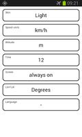
- Dark / Light skin
- Metric / Imperial units
- Multilanguage (currently English, Spanish, Portugese, French, Russian, Chinese, Vietnamese, Czech, Japanese, Korean, Polish, Hungarian)
- Map can be fullscreen or split screen with real time flight data
- GPS / GLONASS Satellites real time display depending on your device capabilities
- Sunrise and sunset at present position
Please note that Flight Map FREE is heavily dependent on the quality of your device's GPS capabilities. Wenn Ihr Gerät A-GPS (unterstütztes GPS) in der Lage ist, führen Sie die Anwendung vor Ort aus, damit die Positionen der Satelliten aus dem Internet heruntergeladen werden, es ist für das Gerät viel einfacher, Signal in der Luft aufzunehmen.
Please share your experience with various devices. Meistens funktioniert Flight Map FREE , wenn Sie auf einem Fenstersitz sitzen, und funktioniert nicht zu gut, wenn Sie zwei Sitze aus dem Fenster oder mehr aus dem Fenster sitzen. Auf jeden Fall empfehlen wir, das Gerät in das Fenster zu verschieben, es zuerst das Satellitensignal aufzunehmen und dann zu versuchen, wie weit das Fenster vom Signal abgeholt werden kann. The screen showing the visible and used satellites is designed to help you with this.
If your device is capable of receiving GLONASS signal, the satellites are shown with a differently colored border. If you want to translate Flight Map FREE into your language (or correct our translation), please contact the developer. The first run of the application takes a while because it needs to unpack the whole world map to be able to display it.
Polish translation thanks to Tomasz Pryca
Hungarian translation thanks to Dr. Istvan Lunczer
Mehr lesen