Naviator is an aviation moving map GPS app made by pilots, for pilots.
This is a 30 day free trial of Naviator . Please see the "Subscription Information" section below for more details.
Notice: we do not provide customer support via Play Store reviews. Please contact our Support Team for customer support issues.
Naviator is a full-featured moving map GPS app for pilots.燃料の1時間未満で、数年前に数千ドルかかるGPSナビゲーションテクノロジーにアクセスできます。
Quickly and easily share your flights with your friends on Naviator Hangar! (http://hangar.Naviatorapp.com/)
特徴:
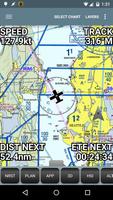
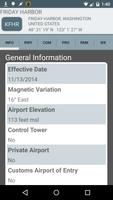
• GPS moving map with airspace, airports, radio navigation aids, airway intersections, TFRs
• All navigational data is downloaded to your device - no internet connection is required while you are flying
• Easy "rubber band" flight planning
• Ilevil AW/SW 、 Dual XGPS 170およびXGPS 190 、 Navworx 、 SkyGuardTWX 、 Flight Data Systems Pathfinder 、 Stratux 、 Flightbox 、Uavionix Pingbuddy、およびフリーフライトシステムのさまざまなレシーバーを含むADS-Bレシーバーのサポート
• Integrates with ADS-B or the Zaon XRX for real-time traffic display
•新しい! AOPA members can import their stored routes from the AOPA Flight Planner
•新しい! Import custom airspace from OpenAir airspace files
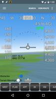
• 3D synthetic vision with terrain, obstacles/towers and runways
• Global terrain database with terrain warnings
• Global Forecast Engine provides winds aloft anywhere on the planet up to 54,000 feet
• GPS track recording - upload your flight recordings to your own personalized Naviator Hangar (http://hangar.Naviatorapp.com)
• Import routes from other flight planning systems using the GPX format
• Integrates with Microsoft Flight Simulator and Prepar3D
• Integrates with X-Plane using the "X-Plane to GPS" app (https://play.google.com/store/apps/details?id=com.appropel.xplanegps)
• Get a weather briefing and file a flight plan from right inside the app
• Vertical navigation (VNAV) calculator
• Canadian data including airspace, airports, navaids, terrain and weather
• NMEA output - Naviator can drive your aircraft's autopilot
• "Bring Your Own Charts" - you can import custom maps and charts into the app. See our forum for more details.
Our support forum is located at http://forum.Naviatorapp.com/
SUBSCRIPTION INFORMATION:
Subscriptions provide access to all app, chart and data updates for the duration of the subscription.
PRICING:
Naviator is free of charge for the first 30 days of use. After this free trial period, the following items may be purchased:
(a) 30 Day Chart Subscription - $4.99 USD
Enables full app access for 30 days*
(b) 1 Year Chart Subscription - $34.99 USD
Enables full app access for one year*
(c) Unlock Naviator - $14.99 USD
米国で飛行しないパイロットを対象としたこの1回限りの充電は、FAAアプローチプレート、セクション、TACS、IFR enoteチャート、TFR更新、「BYOC」機能を除き、 Naviatorのすべての機能を永久にロック解除します。
Includes database updates, weather updates, high-detail VFR base map, terrain database and 3D synthetic vision
* geo-referenced approach plates require an optional subscription from Seattle Avionics. See our website for details.
続きを読む