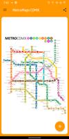
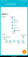
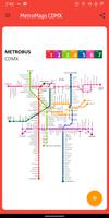
Maps highest quality of transport systems CDMX
With this application you will have the easiest and most accessible way to consult the maps of transport systems such as:
- Metro of Mexico City
- Metrobus in Mexico City
- Light Rail
- Suburban train
- Cablebus
All with a unique quality!
+ Maps made by us exclusively for you, no "copy paste" maps from other applications.
+ Unique large images (UHD). NO MORE hard-to-read pixelated images.
+ Spectacular zoom in the maps for a much better visualization.
+ Design based on Google Material Design.
+ Exclusive floating button to know the stations closest to your position.
+ Route generator, it gives you information such as how much time you will do and which stations to transfer
+ You should not wait to navigate between annoying menus every time you want to consult the stations of the metro network, just open the application and consult, it's that easy!
+ Use double tap on a specific part of the map to perform a quick zoom.
+ Use the drag gesture to move easily throughout the network.
+ Use zoom in and zoom out gestures to resize the map to your liking.
Your opinion is important, send us your suggestions.
Read more