Offline topographical map of Slovakia with hiking trails, peaks, POIs, ...
该应用程序包含一张斯洛伐克的离线地形地图,其中包括现有的远足径,山峰,高程轮廓,旅游地点等。 The application can record your trek and then show it on the map, calculating the statistics and rendering the elevation profiles. Your recorded trails can be also easily exported to GPX and KML format. The map scale is 1 : 35,000.
应用功能:
- shows your current position on the map,
- searches locations on the map (requires internet connection),
- shows current coordinates, elevation, and accuracy of GPS,
- records your track (also while running in background),
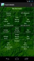
- calculates your recorded track statistics (distance covered, duration, elevation gain, speed, ...),
- renders elevation profiles,
- exports your recorded track into GPX or KML file (file is either saved on memory card or sent by email),
- adjusts GPS accuracy (lower accuracy settings extend the battery life).
The map in this application was generated using data from the OpenStreetMaps project. This data is licensed under (c) OpenStreetMap contributors. The map tiles and design is licensed under (c) Daniel Tekel.]
Important warning: Do not substitute the application map for the official hiking maps in your area. The application map currently covers approximately 90% of the existing trails. The author of this application assumes no responsibility for any map inaccuracies.
阅读更多信息