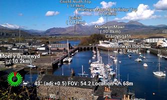
Augmented reality app showing names of hills and mountains in a camera view
Show Me Hills is an application which shows the names of hills and mountains superimposed over the camera view (augmented reality!). Contains 325,185 peaks from all over the world! A version just for the UK also exists (for those who prefer a smaller database - see link below).
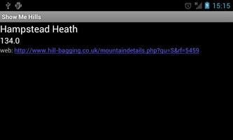
When you look at the landscape using the camera labels giving the mountain names are superimposed directly over the view. The labels can show the distance to the mountain peaks, the bearing, and the height of the mountain.單擊標籤顯示有關峰值的信息,其中包含指向更多信息的鏈接(如果您具有Internet訪問 - 應用程序的其餘部分在不訪問時可以正常工作!)。
Useful for walking and hiking when you want to know the names of the hills and mountains you're looking at!
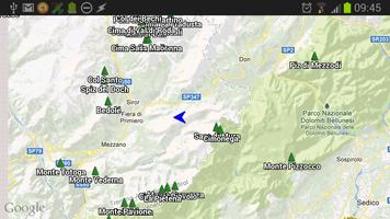
You can switch to a Google Map view which also shows the peaks, plus your location and direction of view.
Show Me Hills is an experimental application that is extremely dependent on your GPS location and handset's compass bearing. If either are inaccurate then the names will appear in the wrong positions.由於許多手機上的指南針非常不可靠,這可能會令人沮喪 - 應用程序確實具有可以抵消可以幫助的指南針的功能,並且執行8個指南針校準的數字也可以幫助您。 There are also user options for tweaking the smoothing of compass readings.
While using the camera view you don't need Internet access, but if you switch to the Google map view you'll need it for the maps.
Mayeul Kauffman已從OpenStreetMap提取了山峰數據庫 - 這是一項了不起的工作,將山峰的數量從數百到幾百萬中的三分之一!
The app can be moved to the SD card if required, although the database is only about 10Mb, so it's not as large as you might imagine.
UK only version: https://play.google.com/store/apps/details?id=com.showmehills.showmehillsuk
這是根據GPLV3許可發布的免費開源申請,歡迎開發人員在https://github.com/showmehills上貢獻
If you come across any problems, please report to the email address: [email protected]
Future plans:
* filtering by prominence
* keep on improving the dataset
* allow photos to be taken with the names
* allow users to report their position to OpenStreetMap
* alternative apps using the same technology (ie a ShowMeTowns type app)
閱讀更多信息