Integrated Charts, Weather, Augmented Reality, Cruising Guidance, and more..
統合されたチャート、天気、拡張現実、クルージングガイダンス、AIS、ソーシャルネットワーキングなどで写真を入手してください...すべて無料でスマートフォンに!
CHARTS (Currently only providing coverage for the US)
- NOAA electronic charts
- Satellite imagery, topographic maps, roads
- NEXRAD and similar live weather
- Overlays showing important warning zones (such as weather, security, etc.)
AIS-i
- Lets you see AIS-i and B traffic without needing an expensive receiver
- Gives you unparalleled emergency safety thanks to Instant Position Reporting
- Provides clear identification of other vessels: type, size, speed, heading, etc.
- Operates over cellular networks
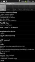
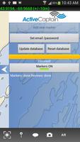
ACTIVE CAPTAIN CRUISING INFO
(constantly updated, user-generated content)
- Navigation information, pilotage, insiders' typs, etc.
- Marinas (fuel types, prices, etc.)
- Dockage (prices, requirements, etc.)
- Pump-out services, ramps, etc.
- Recommended anchorages with details
- レビュー
- Contact info
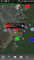
AUGMENTED REALITY VIEWS
Your phone or tablet gives you an invaluable view into what's obscured by fog or darkness. You'll see buoys, channels, hazards, and more, so you can navigate safely to your destination regardless of visibility.
SOCIAL NETWORKING ON THE WATER
- Chat boat-to-boat with friends and fellow boaters
- Join discussions with like-minded boaters in chat rooms
- Share pictures
- Share waypoints, zones, and other locations
- Quickly find your friends out on the water and in harbors and anchorages
Smart Chart AISの開発は、中小企業のイノベーションおよび研究プログラムである契約#D12PC00364の下で、米国の国土安全保障の国土安全保障の脱退によってサポートされています。
© Copyright Team Augmented Reality Inc 2014 All rights reserved
続きを読む