Integrated Charts, Weather, Augmented Reality, Cruising Guidance, and more..
통합 차트, 날씨, 증강 현실, 순항 지침, AIS, 소셜 네트워킹 등으로 사진을 찍으십시오.
CHARTS (Currently only providing coverage for the US)
- NOAA electronic charts
- Satellite imagery, topographic maps, roads
- NEXRAD and similar live weather
- Overlays showing important warning zones (such as weather, security, etc.)
AIS-i
- Lets you see AIS-i and B traffic without needing an expensive receiver
- Gives you unparalleled emergency safety thanks to Instant Position Reporting
- Provides clear identification of other vessels: type, size, speed, heading, etc.
- Operates over cellular networks
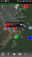
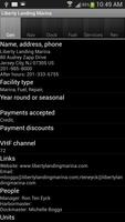
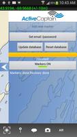
ACTIVE CAPTAIN CRUISING INFO
(constantly updated, user-generated content)
- Navigation information, pilotage, insiders' typs, etc.
- Marinas (fuel types, prices, etc.)
- Dockage (prices, requirements, etc.)
- Pump-out services, ramps, etc.
- Recommended anchorages with details
- Reviews
- Contact info
AUGMENTED REALITY VIEWS
Your phone or tablet gives you an invaluable view into what's obscured by fog or darkness. You'll see buoys, channels, hazards, and more, so you can navigate safely to your destination regardless of visibility.
SOCIAL NETWORKING ON THE WATER
- Chat boat-to-boat with friends and fellow boaters
- Join discussions with like-minded boaters in chat rooms
- Share pictures
- Share waypoints, zones, and other locations
- Quickly find your friends out on the water and in harbors and anchorages
Smart Chart AIS 의 개발은 소규모 비즈니스 혁신 및 리서치 프로그램 계약 #D12PC00364에 따라 미국 국토 안보부에 의해 지원되었습니다.
© Copyright Team Augmented Reality Inc 2014 All rights reserved
더 읽어보세요